

Road traffic video technology is a non-intrusive system that serves to detect the movement of identifiable entities that inhabit the road, which in return is used to generate informed decisions that can enhance safety measures, increase the efficiency of traffic flow, and manage deployed assets.

ATS Traffic is Cubic’s exclusive partner across Canada.
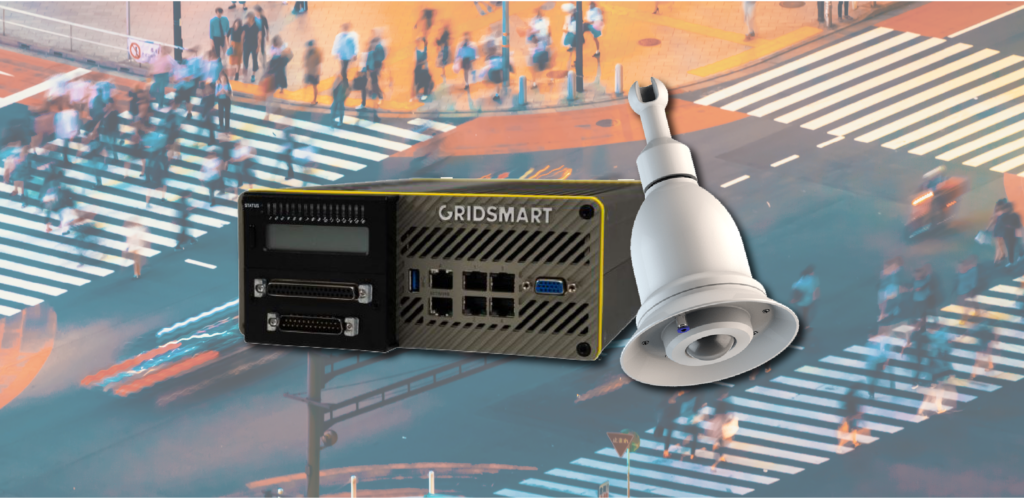
GS3 Processor & Bell Camera
The GS3 processor can be shelf- or rack-mounted and is housed in rugged, anodized aluminum. It supports 2 bell cameras and 2 advanced detection cameras.
The waterproof & dust-tight Bell Camera features the transportation industry’s only horizontal view that can track vehicles entering and exiting the intersection, as well as turning movement.
Processor Data Sheet Bell Camera Data Sheet Shop Now
Data Collection Services
ATS Traffic has the technological capabilities and expertise to gather data and convert it to an efficient traffic solution that will enhance your infrastructure. We have the knowledge and experience to give you exactly the traffic data you need.
LiDAR Applications
LiDAR is utilized by transportation engineers and by our team to gather intel on roads through any road traffic video, to extract key infrastructure data as well as deployed signs and traffic equipment for inventorying and asset extraction through traffic video analysis software. A traffic video detection system can give you a whole new perspective on the way you see the road.
Video and LiDAR Services from ATS Traffic
- Asset Extraction and Inventorying
- Traffic Data Collection and Analysis
- Temporary Conflict Analysis
- Non-Intrusive Video-Based Parking Solutions
- Smart Work Zone Video Solutions
- Wrong-Way Detection
- Detection Solutions
- Custom Video and Security Solutions

Turnkey Traffic Solutions
Precise traffic monitoring and valuable safety analytics. This new solution combines Ouster’s award-winning LiDAR sensors and Bluecity’s powerful artificial intelligence (AI) software to monitor traffic networks and public spaces. It generates real-time mobility and safety data analytics with predictions, helping to improve traffic and crowd flow efficiency, advancing sustainability, and protecting vulnerable road users.

Mobile Mapping
In a single survey pass, Nektar technology can create a highly detailed three-dimensional representation of the surrounding environment. Nektar 3D Mobile Mapping uses cutting-edge LiDAR technology to accurately survey terrain and infrastructure elements. Applications include transportation infrastructure mapping, surface management mapping, and parks & recreation mapping.